William Smith’s
Geological Map of England and Wales and Part of Scotland, 1815-1817
("The Map That Changed The World,"1 well, yes and no)
Together with Illustrations from some of the Geological Maps of the Period
This is the title of the recent best-seller by Simon Winchester. It is a popular account of Smith’s life and his great map. The author’s enthusiasm is contagious and the reader is likely to finish the book with a wealth of information about William Smith and his times.
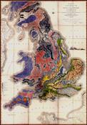
The map itself displayed in whole is an extraordinary sight. Its size alone - about 6 feet across by 9 feet high - is dramatic. The territory mapped in detail encompasses thousands of square miles. It is well over 500 miles from Lands End to the Firth of Tay. Smith had begun his efforts to publish such a grand map about 1802 and he was early encouraged by the enthusiastic support of Sir Joseph Banks, President of the Royal Society of London, who headed the subscription list with 50 pounds - a considerable sum at the time. It was equal to half of the Royal pension that was later awarded to Smith for his accomplishment.
Ten years passed with little progress beyond Smith’s continual additions and refinements until in 1812, John Cary, a surveyor and engraver, agreed to bear the brunt of the considerable costs of the enterprise. Cary was at that time England’s foremost mapmaker and publisher of maps. He had the resources and the assistants to prepare a national topographic map 74" or 6 feet 2 inches wide by 105" or 8 feet 9 inches high in order to meet Smith’s specification of 5 miles to the inch.
Cary’s base map was in itself a great achievement. Because of its size it was printed as 15 separate copperplate engravings 2' x 1'8" in size. To meet Smith’s rigid requirements each sheet was drawn and engraved separately to show the natural topography, streams, mud flats etc. Literally thousands of local names had to be ascertained (many for the first time) and engraved. As the base engravings were pulled, the geology was water-colored in by hand--the same procedure that produced Audubon’s "Birds of America". Color lithography would not come into use until much later. Cary’s map publishing establishment would have employed a number of girls to do the coloring under Smith’s direction. The skills of these colorists must have been very high since the complex boundaries of the different formations were not engraved on the map but were instead indicated by the shading. The color of each formation deepened and darkened towards the bottom. Over the several years between the appearance of the first sheets and the final sheet Smith made continual corrections and modifications so that there are some changes and color modifications at the sheet borders and even between copies.
Roughly four hundred copies of the map were printed and signed by Smith beginning in 1815 with some finished as late as 1817. Only about one hundred are believed extant. The copy reproduced here is numbered a65 and was signed between 18 Dec. 1815 and 23 Jan. 1816. (Eyles2). It was sold as 16 sheets (the 16th was an index?) boxed with a memoir for "5l,5s", or "on canvas and rollers...7l, varnished 8l...In case for traveling 8l.. on spring rollers 10l":--probably $1200 to $2500 in today’s money. Serious geologists among the purchasers would have bought the box of separate sheets and had them backed with linen and then folded to a manageable size so that they could be carried into the field. Copy a65 reproduced here was so mounted and folded although probably never mounted as a single sheet. It survives now on three separate composite pieces--the first and second consisting of two rows of three each, with a third row of the last three sheets making 15 in all.
Because of its rarity and its size it is difficult to display and even more difficult to study. Few geologists or historians of science have ever seen a copy. There are several places where the map is displayed as for example on the wall of the private meeting rooms of the Geological Society of London (behind a shade) but I do not know anywhere that it is open to public view. Because watercolors fade rapidly under ordinary light, libraries and museums fortunate enough to own a copy, store it carefully and expose it only under exceptional circumstances.
Note the legend on the map (bearing Smith’s title "Explanation") with colored and shaded tablets in the correct order from the London Clay on top to the Killas and then the Granit, Syenit, and Gneifs (sic) at the bottom. It is improbable that Smith or anyone else in 1815 understood from this ordering of the strata in the legend, the significance of this prototype of the Geologic Column or thought to draw from it, the concomitant geological scale of time. But it was there even if it would take years before the Geological Time Scale would be made explicit. Few ideas in the history of thought approach the importance of the discovery of what Stephen Jay Gould called "deep time" manifest in the Geological Time Scale.
To emphasize what Smith considered his greatest achievement--he was the first to discover that the strata of England were in a definite order and the first to show that their fossil contents were in the same order--he published an ordered column of colored tablets that he referred to as a geological column of organic (organized) fossils in 1816 while copies of the map were still printing. (see Contents, Part III). For all its complexity the map itself was incomplete without the concomitant ordering of the fossils. Smith was probably the first to understand that both the strata and their fossil contents were in such a natural order and that it was an order of indefinitely wide extension, i.e. from local quarries to the whole of England and beyond.
The naturalists of the time who studied geology were bemused by the debates between the followers of James Hutton and the students of Abraham Gottlob Werner whose theories of the earth had little bearing on Smith’s discoveries and offered no research program beyond mineralogical and petrographic description. As for the fossils, the greatest naturalists of the day, specifically Georges Cuvier, had spent their careers fitting them into their proper biological classification. What Smith had understood was that there was a parallel stratigraphic classification. Whether or not unwittingly, he had introduced the dimension of time to biology and transformed the science of geognosy to a historical science of the earth and life.
The principle of superposition--that the lower of two strata found in a sequence was deposited earlier and hence it was the older--had been discussed by geologists since at least the time of Steno (latter 17th Century) but this was considered of no more temporal significance than the fact that the first floor of a house is built before the second. Smith’s clergymen friends in fact considered his discoveries as a natural vindication of the Creation as recounted in the Book of Genesis.3 The intellectual leap from Smith’s legend to the Geologic Time Scale would demand a greater transformation of fundamental belief than that demanded when Copernicus set the earth in motion.
Although his map was well received, Smith had little profit from it. The officers of the Geological Society of London, principally George Bellas Greenough published a rival map largely copied from Smith at a lower price but this too sold few copies. There were not that many geologists and at least one harried academician protested that he "could not afford it". Smith’s financial difficulties brought him to debtor’s prison. Released through the efforts of friends, Smith next embarked on the preparation of geologic maps of individual counties in much greater detail. Again John Cary printed the base maps. Twenty-one of these county maps (out of a projected 60) were completed before this venture too, petered out although the price was only 5 shillings. These county maps were without tables or columns of strata as legends. Instead, Smith placed the colored tablets with their identifying names of the strata individually in the blank space surrounding the county boundary, each as close to the particular stratum as possible, cf. Smith’s maps of Oxfordshire and Gloustershire. From an aesthetic point of view, they surpass even the great map, while the detail is proportionately greater than anything earlier.
We know that Smith understood the significance of his discovery in 1799, the date of the first table that he dictated to his friends Richardson and Townsend. But the great map that he published in 1815 was neither the first geological map of the 19th Century nor the first to show an ordering of the strata and to make use of the accompanying ordering of their fossil contents. Smith’s Paris rivals, Georges Cuvier and Alexandre Brongniart published such a "Geognostique" map of the Paris Basin in 1808, seven years before Smith’s map and republished it in 18114 and again in 18225 Both scientists were part of the extensive scientific establishment of France, by far the largest and most handsomely endowed in the world. Cuvier, the father of comparative anatomy, was dubbed the Napoleon of Science. His eminence, honors and rewards continued scarcely interrupted by the Revolution, through Napoleon’s Empire and the Bourbon restoration. Both men worked from the Museum National des Sciences Naturelles where their colleagues such as the Chevalier de Lamarck were publishing the results of their studies of specimens of fossil and living species of shell fauna from all over the world. Their map was at almost the same scale as Smith’s--ca. 4.7 miles to Smith’s 5 miles to the inch, but covered only a fraction of the area. The Paris basin was little larger than the London basin and the whole was less than a fifth of the area mapped by Smith. Where Smith distinguished 23 formations over hundreds of miles, Cuvier and Brongniart traced 11 formations over a few tens of miles. Although Smith dealt mostly with strata that scarcely deviated from the horizontal, he did not hesitate to tackle highly contorted strata as for example the vertical beds exposed on the Isle of Wight. By contrast the strata of the Paris Basin were close to horizontal. As of 1811, Cuvier and Brongniart did employ fossils but only in the few instances where more obvious evidences of sequence were absent. The title of their work was Géographie Minéralogique by which they meant the distribution of what Werner had called the "external" characteristics of the mineral and fossil contents, shapes, colors, and textures of the strata within the Paris basin. We would today call this lithology. They determined the order of the strata from their superposition, their lithology and by tracing them across the basin. They showed this in the colored cross-sections (coupes) that accompanied their map including a schematic construct of a composite cliff side showing the sequence of all the strata of the basin4. They proved their work by the leveling shown in their coupes.
Were they historical in their intent? Part of the rationale of the study was to understand the significance of the large fossil vertebrates that Cuvier had analyzed zoologically, but had no known modern representatives. And what was the significance of the fact that traces of contemporary large vertebrates were not found as fossils? Jean-Baptiste, Chevalier de Lamarck had drawn the obvious explanation of evolution as early as 1800, but on such sparse evidence that it seemed unnecessary to bring down the heavy artillery of the Church to silence him. Cuvier and Brongniart described the fossils of the Paris basin (identified by colleagues such as Lamarck at the Museum). Where Smith’s text, always practical, dealt with the soils, drainage, and uses of the strata--the applications--of his strata, Cuvier and Brongniart used lithology and fossils to deduce the origins of the different strata in incursions of the sea, and to describe alternations between inland freshwater strata and periods of aridity.
Yet I would claim that as of 1811, they had no more grasped the concept of geologic time than James Hutton in the 18th Century when he wrote that a granite intruding a sediment was younger than the sediment intruded. In the Legend, or vertical block of tablets of distinct colors used to identify the strata of corresponding colors of the Cuvier and Brongniart map, the column was reversed with their lowest stratum (the Craie or Chalk) on top and their uppermost stratum (the alluvium of the Seine riverbed) on the bottom. They knew the correct order of succession of course and showed it in the colored cross-sections (coupes) that accompanied their map including a schematic construct of a composite cliff side showing the sequence of all the strata of the basin4. The reversal of the order of superposition in their legend is a demonstration of their failure to grasp the historical dimension of their studies and this is proven by their subsequent conversion to Smith’s geology (cf.below). In 1811 their meticulously constructed map owed little to the widespread dissemination of Smith’s ideas after 1799 when he first dictated his "Table of the Strata" to Townsend and Richardson. Cuvier and Brongniart had determined the order of the strata of the Paris basin from their superposition, their lateral extension and their lithology and proven it by leveling as shown in their coupes4.
When in 18225 they republished the same map, Cuvier and Brongniart put their column of colored tablets in the correct order-standard usage ever since. Though their map itself was hardly changed, the greatly enlarged volume now included plates of the fossils found in each of the fossiliferous strata--directly comparable to the engravings of Smith’s "Strata Identified..." and since the strata were essentially the same as those of the London Basin, the fossils were essentially the same. In 1821, Brongniart had already published a succinct and far more sophisticated exposition than Smith’s accounts, of the principle of faunal succession, On the Zoological characters of formations with the application of these characters to the determination of some rocks of the Chalk formation, insisting that "the characters...drawn from the analogy of organized bodies...[are] superior to all other differences, however great they may appear"6. Concentrating on the Paris basin and with the resources of the Museum National, they distinguished many more species and genera than Smith. This time they employed the principle of faunal succession, using Smith’s work among others to compare the London and Paris basins in two generalized maps on the same page. The same legend suffices for both basins. Cuvier and Brongniart wrote that similar basins of the same strata with the same fossils and the same alternations of marine and freshwater deposition were described in many parts of Europe and they understood this as a temporal sequence immediately before the surficial deposits. Their second legend then is very close to--if not actually--a true Geologic Column.
In yet another example, the Legend to William Maclure’s 1809 "Map of the United States of America" even in its 1817 reissue not only inverts the order of superposition of the Wernerian formations from the Primitive to the Alluvial (modern deposits of sands, gravels, etc. by rivers or streams), but places the only non-Wernerian formation distinguished on his map--the Old Red Sandstone--below the Alluvial. Maclure’s legend then was not intended to show any ordering of the formations--a concept that had not crossed his mind. It was simply a key to their identification
The use of colors on a two dimensional map to add a third dimension of lithology (i.e. rock characteristics) was not a novelty at the beginning of the 19th century. Such a map accompanied the Paris edition "Carte Minéralogique du Comté de Glatz" of Leopold von Buch’s pamphlet on the district of Landeck published originally in German in 17977. The map bears a column of eight tablets identifying eight separate rock types (basalt, greenstone schist, etc.) but without any obvious implication of order or succession. A student of Werner’s, Buch believed that such questions were settled in Werner’s Geognosie. Werner’s formations were fixed. The map was to show the distribution of the Minéralogie, which in turn fixed the position in Werner’s System.
Buch’s rocks moreover were far more complex than Smith’s slices of buttered bread. Geognosticly speaking most of them were comparable to the nonfossiliferous "Granite, Sienite, & Gneifs" lumped together at the base of Smith’s Table. Buch’s master (Abraham Gottlob Werner) placed such rocks in his Primitive category. Unable to unravel this complexity, Buch’s map appears simple by comparison, but the true comparison would be to the small part of the Smith map devoted to the bottom one or two tablets of his column. Buch’s book with its uncolored map would have been sold as printed sheets. Binding the book and coloring the map was left to the purchaser. Buch owed nothing directly or indirectly to Smith’s work either in this, his first geological publication, or later in 1802, the date of publication of Volume I of his "Geognostical Observations..."7with its larger and more detailed Mineralogische map. Like Werner, Buch deliberately rejected temporal significance in the order of the formations distinguished in his map of 1802 when he placed the key of colored tablets in a horizontal row in the correct sequence starting with the lowest primitive at the left and proceeding with the next lowest etc. to the uppermost sedimentary formation at the right. To Werner, there was no more significance to the superposition of his formations than there would be to the layers of a cake. Buch’s designation of an older and a newer sandstone shows that he understood the principle of superposition. He simply saw no significance in the relative ages of the Flotzgebirge strata. In any event, Werner’s geognosy was an intellectual luxury, a frill at the Freiberg School of Mines in the heart of the East German mountains, so rich in gold and silver.
J.J. D’Omalius D’Halloy prepared a "Sketch of a Geological Map of France, the Pays-Bas, and neighboring Countries" in 1813 but it was only published (in the official Annales des Mines) in 1822 and reprinted in England in H. T. de la Beche’s "Selections..." in (1824)6. The legend (labeled Explanation of the Colors) shows six tablets in generalized groups separated at that time from an uppermost class of the output of active volcanoes and rocks such as basalts which by their mineralogy, chemistry and texture were evidently of volcanic origin. In the accompanying text he explained that rocks of this character were found in different positions in the general order of succession. The same was true of the formations that he recognized as Werner’s Primitive and Transition which he therefore renamed Primordial and placed in his lowest and earliest group. He was clearly concerned with the temporal succession of the four intermediate formations but made no use of the principle of faunal succession. His map of an area much larger than England and much smaller than Maclure’s United States, should be taken as representing the state of the science on the eve of the breakthrough that William Smith’s great map brought about.
There is no point in speaking of the first geologic map. Lines and hieroglyphs on an early dynastic papyrus have been described as a map of the gold-workings in Upper Egypt. As to Smith’s priorities and originality, his nephew and protégé John Phillips did not consider an account of the setting in which Smith’s work evolved as in any way detracting from the magnitude of Smith’s achievement. In his Memoirs in 1844, Phillips discusses the work of more than a dozen geologists before Smith in England alone, among them Martin Lister whose proposal for a geological map dated back to the 17th century. Lister’s contemporary, Robert Hooke cited almost a dozen learned natural historians of the 17th century when he proposed that fossils were the hieroglyphics of nature by means of which a geologic history might be constructed. Phillips could have gone much further back. Georg Bauer (Agricola, another reputed father of geology) in his book "De Natura Fossilium" of 1546. cited an even 100 sources going back to classical antiquity.
Only a few years after Lister, Edward Lhuyd argued for fossils as guides to the ages of the containing strata comparing this method (in Hooke’s simile) to dating a Roman monument from coins found in the ruins. In the 17th and 18th centuries, equivalent volumes on geology were produced in Italy and the same might be said for much of the rest of Europe-sharing as it was a common culture. Nor was this work carried on in isolation. Almost all the nations of Europe and European derivation boasted libraries, universities academies of science and learned societies with journals devoted to the sciences, particularly to natural history. Their secretaries and associates exchanged letters and publications. Savants learned in natural history enjoyed the patronage of royalty, nobility and clergy. Commoners like Smith may not have studied at one of the great universities but the influence of the universities pervaded the culture and the society that nourished his developing mind.
What Smith had accomplished was to open up a science that was saturated with theory but starved of data. A pioneer, he showed geologists a new phenomenological landscape of such fertility that we today, nearly two centuries later, with the recent extensions of the geologic mapping technique to the bottom of the sea and the Lunar and Martian landscapes, can still recognize his influence. That the great transformation of geological science may have owed more to the adoption of the principle of faunal succession at Paris under the influence of Cuvier and its eloquent exposition by Brongniart than to Smith’s failed attempts at publication, does not detract from the magnitude of his discovery. With respect to the sheer impact of Smith’s great map, no one who has seen it at its full scale would dispute John Phillips’s characterization of it as; "Perhaps the most varied and beautiful sheets that have ever appeared in geological colors"
Cecil J. Schneer Professor Emeritus of Geology and the History of Science
The University of New Hampshire
Postscript and Acknowledgments
« Return to Table of Contents
1 Harper Collins, New York: 2001.
2 Eyles, J., Item 16 B in; Jour.Soc.Biblphy.nat.Hist.,(1969) 5(2): 87-109, vide pp.97-98.
3 Townsend, Joseph, The Character of Moses established for Veracity as an Historian, recording Events from the Creation to the Deluge, 1813-1815.
4 Cuvier, Georges & Brongniart, Alexandre, Essai sur la Géographie Minéralogique des Environs de Paris, 1811, p.271 Pl. I: Fig. 1[of 11]: " Cette coupe (cut or profile, ~ section) Idéale et générale... represents the position of all the terrains of the environs de Paris supposed as reunited in a single hill, in the manner that they are represented on the coupes, and with the colors which may be used to distinguish them and that are employed for that purpose on the map". Five of the remaining ten figures in C&B 1811, are coupes or profiles taken along lines drawn from Notre Dame de Paris out to the West, Northwest, North, East and South on a scale of 1.5km/cm. The lines cover ~20-25 km; the vertical exaggeration is 1100:1; and the scale of the map itself is 2km/cm; area ~150km by ~130 km.
5 C&B, Description Géologique des Environs de Paris, 1822. The map is printed from the same Plate (Carte Géognostique des Environs de Paris,1809) with little modification but the text is greatly expanded and advanced.
6 Annales des Mines (1821) transl. by H.T.de la Beche, Selection of Geological Memoirs Contained in the Annales..., London, Phillips, 1824.
7 von Buch, L., Geognostische Beobachtungen..., Vol I, Berlin: 1802.